Argentina Map - Editable Map of Argentina - Template for PowerPoint
Argentina Map - Editable Map of Argentina - Template for PowerPoint - 2-5 is backordered and will ship as soon as it is back in stock.
Couldn't load pickup availability
Premium Features
Premium Features
- Resizable without loss of quality
- Fully editable in Size and Color
Download Information
Download Information
You receive an email with download link after your purchase.
Compatibility
Compatibility
These slides are compatible with all Microsoft PowerPoint Versions newer or equal to 2003.

Argentina Map - Editable Map of Argentina - Template for PowerPoint
Premium Slides for PowerPoint.
Stand out and enhance your presentation with hiqh quality slides.
Description
Description
Premium PowerPoint Map of Argentina. This detailed PowerPoint Map Template shows Argentina with states names and biggest cities including the Argentina capital.The Argentina PowerPoint Map is hand drawn and fully editable in size and color. Every state can be extracted simply.
Specific territories can be highlighted easily with just 2 clicks in PowerPoint. The extensive Map Guide, which is included in this package, shows the easy steps of adjusting the map to your needs.
Specifications
Specifications
-
Slides
-
Delivery time
-
Powerpoint Version
-
Selection List (Maps only)
-
License
-
Editable
-
Color Variations
Payment & Security
Payment methods
Your payment information is processed securely. We do not store credit card details nor have access to your credit card information.
The map template of Argentina includes the following states:
Buenos Aires, Catamarca, Chaco, Chubut, Córdoba, Corrientes, Entre Ríos, Formosa, Jujuy, La Pampa, La Rioja, Mendoza, Misiones, Neuquén, Río Negro, Salta, San Juan, San Luis, Santa Cruz, Santa Fe, Santiago Del Estero, Tierra Del Fuego, Antártida E Islas Del Atlántico Surb, Tucumán,, Azul, Banda del Río Salí, Barranqueras, Béccar, Belén de Escobar, Bella Vista, Bernal, Bosques, Boulogne Sur Mer, Burzaco, Campana, Caseros, Castelar, Chimbas, Chivilcoy, Cipolletti, Ciudad Evita, Ciudad Jardín El Libertador, Ciudadela, Clorinda, Comodoro Rivadavia, Concepcion, Concepción del Uruguay, Concordia, Don Torcuato, El Jagüel, El Palomar, Eldorado, Ezpeleta, Florencio Varela, Florida, General Pico, General Roca, General Rodríguez, Glew, Gobernador Julio A. Costa, Goya, Grand Bourg, Gualeguaychú, Guernica, Isidro Casanova, Ituzaingo, Junín, La Banda, La Rioja, La Tablada, Libertad, Lomas de Zamora, Lomas del Mirador, Longchamps, Los Hornos, Los Polvorines, Luján, Luján de Cuyo, Maipú, Mariano Acosta, Martínez, Mendoza, Mercedes, Monte Chingolo, Monte Grande, Moreno, Morón, Necochea, Oberá, Olavarría, Olivos, Palpala, Pergamino, Presidencia Roque Sáenz Peña, Puerto Madryn, Punta Alta, Rafael Calzada, Rafael Castillo, Rafaela, Ramos Mejía, Rawson, Reconquista, Remedios de Escalada, Río Cuarto, Río Gallegos, Río Grande, Rivadavia, San Carlos de Bariloche, San Fernando, San Fernando del Valle de Catamarca, San Francisco, San Francisco Solano, San Isidro, San Juan, San Justo, San Martín, San Nicolás de los Arroyos, San Pedro de Jujuy, San Rafael, San Ramón de la Nueva Orán, Santa Rosa, Sarandí, Tandil, Tartagal, Temperley, Trelew, Tres Arroyos, Trujui, Ushuaia, Venado Tuerto, Viedma, Villa Carlos Paz, Villa Centenario, Villa Domínico, Villa Elvira, Villa Gobernador Gálvez, Villa Luzuriaga, Villa Madero, Villa María, Villa Mariano Moreno/El Colmenar, Villa Mercedes, Villa Tesei, Virrey del Pino, Wilde, William Morris, Yerba Buena/Marcos Paz, Zárate
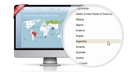
Effortless and fast – the PremiumSlides Selection Lists for PowerPoint Maps
Save your time and select the countries with our comfortable Selection list tool. Click on the desired country and color the shape with one simple click. All countries in the selection list are in alphabetic order and effortless to find. You can also select the state on your map, and the state wil be highlighted in the selection list. Most of our maps are delivered with a selection list. Please check product details. (Due to technical disadvantages of Microsoft Office for Mac, Selection Lists are only available for PC.)

Remarkable features are provided with this map template of
-

The map template of is fully editable in Microsoft PowerPoint
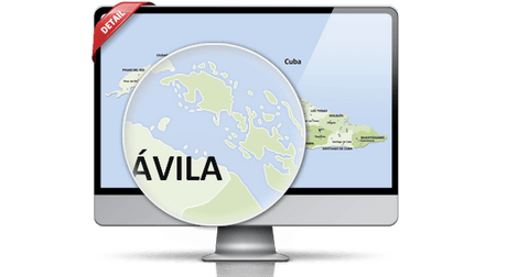
These very detailed PowerPoint maps are totally editable in size and color. Any country, county or state (depending on the map) can be extracted or highlighted. Because of the excellent quality you can resize any map with no loss of quality. This is relevant if you want to print your PowerPoint Slides.
-

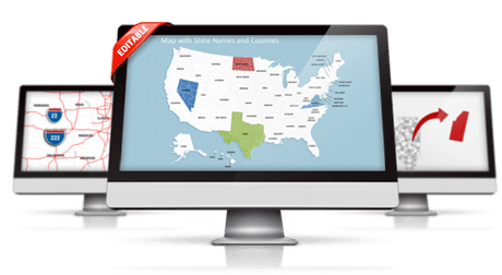
State and Cities are shown on PowerPoint Map
This PowerPoint map is delivered with state and capital name tags. All views are well structured. Country and city tags can be hidden with just one click if you prefer a blank map.
-

Up to 14 Multiple Color themes for are already included
There are up to 14 different color themes shipped with all this PremiumSlides map package. You can switch all colors of your map with just one click. This makes it easy to use maps in your own presentation. The colors have been selected to look great in combination. To making use of PremiumSlides Maps for PowerPoint you do not have to be a design genius to have great looking slides in your presentation.
-

Direct download for Microsoft PowerPoint
We guarantee that all our products work with Microsoft Office newer than Office 2003. You can work with our maps and shapes not only in PowerPoint but likewise MS Word and MS Excel. All files even work on Office for Mac. Only the Selection list add on is not supported by Office for Mac. You do not need any new plugins or any other software! Just launch PowerPoint and work straight away. You can download your purchased map files and slides directly after purchase.
Facts and information about Argentina you can use in your presentation.
Argentina is often referred to as Argentine Republic or simply Argentina. The locals also call the country Republica Argentina or Argentina for short. The origin of the country's name is unclear. The country's flag has the colors light blue, white.
Geographic facts about Argentina
The country of Argentina lies 34 00 south and 64 00 west. The region has a total area of 2,780,400 sq km with a land coverage of 2,736,690 sq km. About 43,710 sq km is covered with water. Argentina has a total border length of 11,968 km and is bordered by the following 5 countries: Bolivia 942 km, Brazil 1,263 km, Chile 6,691 km, Paraguay 2,531 km, Uruguay 541 km. The lowest point is Laguna del Carbon -105 m (located between Puerto San Julian and Comandante Luis Piedra Buena in the province of Santa Cruz) below sea level and the highest is Cerro Aconcagua 6,960 m (located in the northwestern corner of the province of Mendoza; highest point in South America). Its mean elevation is about 595 m. Buenos Aires is the capital of Argentina and can be found 34 36 S, 58 22 W.
Population and life in Argentina
In July 2016 Argentina had a population of 43,886,748 people. In 2015, 91.8% of the population lived in cities. The annual growth rate of urbanization is 1.04%. The residents of the country are called Argentine(s). The Argentine population has a median age of 31.5 years. The median age for males in 2016 was 30.3 years, and 32.7 years for females. The estimated growth rate of the Argentine population in 2016 was 0.93%. Looking at life expectancy, the Argentine people live an average of 77.1 years (males 74 years, females 80.4 years). Statistically, Argentine women give birth to 2.28 children in their lifetime.
Argentina and its economy
The estimated gross domestic product in 2015 was about $972 billion, with a growth rate of 1.2% compared to 2014 (GPD 2014: $960.4 billion, growth rate 0.5%; GPD 2013: $956.1 billion, growth rate 2.9%). The economic sectors of Argentina are: agriculture: 10.5%, industry: 29.1% and services: 60.4% (2015 est.). The country's economy is known for: food processing, motor vehicles, consumer durables, textiles, chemicals and petrochemicals, printing, metallurgy, steel.
Electricity and internet infrastructure in Argentina
Only 96,4% (1.5 million) of the people living in Argentina had full access to electricity in 2013 (rural population: 96%; urban population: 99,2%). Among those 69.4% (July 2015 est.) or 30.142 million Argentines, had access to an internet connection.
How to buy?