Australia Continent Map - Editable Map of Australia Continent - Template for PowerPoint
Australia Continent Map - Editable Map of Australia Continent - Template for PowerPoint - Company License is backordered and will ship as soon as it is back in stock.
Couldn't load pickup availability
Premium Features
Premium Features
- Resizable without loss of quality
- Fully editable in Size and Color
Download Information
Download Information
You receive an email with download link after your purchase.
Compatibility
Compatibility
These slides are compatible with all Microsoft PowerPoint Versions newer or equal to 2003.

Australia Continent Map - Editable Map of Australia Continent - Tem...
Premium Slides for PowerPoint.
Stand out and enhance your presentation with hiqh quality slides.
Description
Description
Premium PowerPoint Map of Australian Continent. This detailed PowerPoint Map Template shows Australia’s countries, country names and capitals. The Australia PowerPoint Map is hand drawn and fully editable in size and color.
Specific territories can be highlighted easily with just 2 clicks in PowerPoint. The extensive Map Guide, which is included in this package, shows the easy steps of adjusting the map to your needs. The Australia Map Template is a great benefit for showing sales and statistic data in different countries.
Do not wait! Get this Premium Australia Map Template today and impress your audience in your next meeting!
Specifications
Specifications
-
Slides
-
Delivery time
-
Powerpoint Version
-
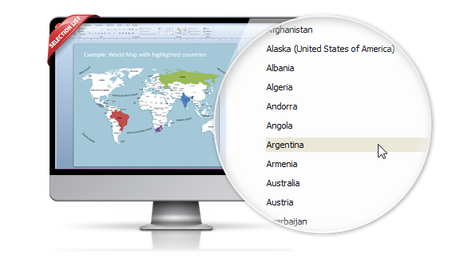
Selection List (Maps only)-
-
License
-
Editable
-
Color Variations
Payment & Security
Payment methods
Your payment information is processed securely. We do not store credit card details nor have access to your credit card information.
Remarkable features are provided with this map template of
-

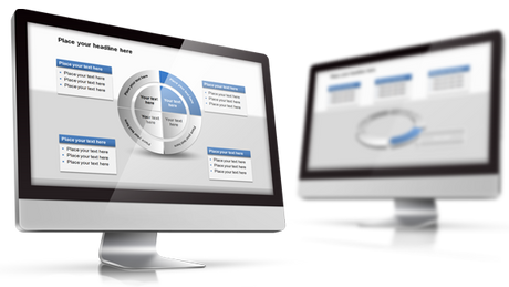
The map template of is fully editable in Microsoft PowerPoint
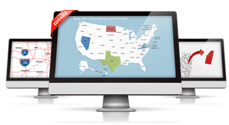
These very detailed PowerPoint maps are totally editable in size and color. Any country, county or state (depending on the map) can be extracted or highlighted. Because of the excellent quality you can resize any map with no loss of quality. This is relevant if you want to print your PowerPoint Slides.
-

State and Cities are shown on PowerPoint Map
This PowerPoint map is delivered with state and capital name tags. All views are well structured. Country and city tags can be hidden with just one click if you prefer a blank map.
-

Up to 14 Multiple Color themes for are already included
There are up to 14 different color themes shipped with all this PremiumSlides map package. You can switch all colors of your map with just one click. This makes it easy to use maps in your own presentation. The colors have been selected to look great in combination. To making use of PremiumSlides Maps for PowerPoint you do not have to be a design genius to have great looking slides in your presentation.
-

Direct download for Microsoft PowerPoint
We guarantee that all our products work with Microsoft Office newer than Office 2003. You can work with our maps and shapes not only in PowerPoint but likewise MS Word and MS Excel. All files even work on Office for Mac. Only the Selection list add on is not supported by Office for Mac. You do not need any new plugins or any other software! Just launch PowerPoint and work straight away. You can download your purchased map files and slides directly after purchase.
Facts and information about Australia you can use in your presentation.
Australia is often referred to as Commonwealth of Australia or simply Australia. The name Australia derives from the Latin "australis" meaning "southern"; the Australian landmass was long referred to as "Terra Australis" or the Southern Land. The country's flag has the colors green, gold.
Geographic facts about Australia
The country of Australia lies 27 00 south and 133 00 east. The region has a total area of 7,741,220 sq km with a land coverage of 7,682,300 sq km. About 58,920 sq km is covered with water. Australia is an island and is not bordered by any country. The lowest point is Lake Eyre -15 m below sea level and the highest is Mount Kosciuszko 2,229 m. Its mean elevation is about 330 m. Canberra is the capital of Australia and can be found 35 16 S, 149 08 E.
Population and life in Australia
In July 2016 Australia had a population of 22,992,654 people. In 2015, 89.4% of the population lived in cities. The annual growth rate of urbanization is 1.47%. The residents of the country are called Australian(s). The Australian population has a median age of 38.6 years. The median age for males in 2016 was 37.8 years, and 39.4 years for females. The estimated growth rate of the Australian population in 2016 was 1.05%. Looking at life expectancy, the Australian people live an average of 82.2 years (males 79.8 years, females 84.8 years). Statistically, Australian women give birth to 1.77 children in their lifetime.
Australia and its economy
The estimated gross domestic product in 2015 was about $1.489 trillion, with a growth rate of 2.5% compared to 2014 (GPD 2014: $1.454 trillion, growth rate 2.6%; GPD 2013: $1.56 trillion, growth rate 2%). The economic sectors of Australia are: agriculture: 3.7%, industry: 28.9% and services: 67.4% (2015 est.). The country's economy is known for: mining, industrial and transportation equipment, food processing, chemicals, steel.
Electricity and internet infrastructure in Australia
100% of the people living in Australia had full access to electricity in 2016. Among those 84.6% (July 2015 est.) or 19.238 million Australians, had access to an internet connection.
How to buy?