


Details about Myanmar Map - Editable Map of Myanmar - Template for PowerPoint
Premium PowerPoint Map of Myanmar . This detailed PowerPoint Map Template shows Myanmar with states names and biggest cities including the Myanmar capital.The Myanmar PowerPoint Map is hand drawn and fully editable in size and color. Every state can be extracted simply.
Specific territories can be highlighted easily with just 2 clicks in PowerPoint. The extensive Map Guide, which is included in this package, shows the easy steps of adjusting the map to your needs.
Remarkable features are included with this map template of Burma

The map template of Burma is fully editable in Microsoft PowerPoint
These exceptionally detailed PowerPoint maps are entirely editable in size and color. Any country, county or state (depending on the map) can be extracted or highlighted. Because of the premium quality you can resize any map without any loss of quality. This is essential if you want to print your PowerPoint Slides.
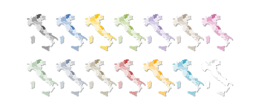
Up to 14 Multiple Color themes for Burma are already included
There are up to 14 different color designs provided with all this PremiumSlides map package. You can modify all colors of your map with just one click. This makes it easy to integrate maps in your own presentation. The colors have been picked to look great in combination. To use PremiumSlides Maps for PowerPoint you do not have to be a design genius to have great looking slides in your presentation.
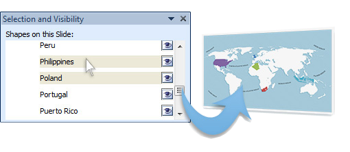
Effortless and fast – the PremiumSlides Selection Lists for PowerPoint Maps
Save your time and select the countries with our comfortable Selection list tool. Click on the desired country and color the shape with one simple click. All countries in the selection list are in alphabetical order and easy to find. You can also select the state on your map, and the state wil be highlighted in the selection list. A lot of of our maps are delivered with a selection list. Please check product details. (Due to technical disadvantages of Microsoft Office for Mac, Selection Lists are only available for PC.)
State and Cities are shown on Burma PowerPoint Map
This PowerPoint map is delivered with state and capital name tags. All views are well structured. Country and city tags can be hidden with just one click if you prefer a blank map.


Direct download for Microsoft PowerPoint
We guarantee that all our products work with Microsoft Office newer than Office 2003. You can work with our maps and shapes not only in PowerPoint but likewise MS Word and MS Excel. All files even work on Office for Mac. Only the Selection list add on is not supported by Office for Mac. You do not need any new plugins or any other software! Just start PowerPoint and work right away. You can download your bought map files and slides immediately after purchase.
Facts and information about Burma you can use in your presentation.
Burma is often referred to as Union of Burma or simply Burma. The locals also call the country Pyidaungzu Thammada Myanma Naingngandaw (translated as the Republic of the Union of Myanmar) or Myanma Naingngandaw for short. Both "Burma" and "Myanmar" derive from the name of the majority Burmese Bamar ethnic group. The country's flag has the colors yellow, green, red, white.
Geographic facts about Burma
The country of Burma lies 22 00 north and 98 00 east. The region has a total area of 676,578 sq km with a land coverage of 653,508 sq km. About 23,070 sq km is covered with water. Burma has a total border lenght of 6,522 km and is bordered by the following 5 countries: Bangladesh 271 km, China 2,129 km, India 1,468 km, Laos 238 km, Thailand 2,416 km. The lowest point is Andaman Sea/Bay of Bengal 0 m below sea level and the highest is Gamlang Razi 5,870 m. Its mean elevation is about 702 m. Rangoon (Yangon); note - Nay Pyi Taw is the administrative capital is the capital of Burma and can be found 16 48 N, 96 09 E.
Population and life in Burma
In July 2016 Burma had a population of 56890418people. In 2015, 34.1% of the population lived in cities. The annual growth rate of urbanization is 2.49%. The residents of the country are called Burmese (singular and plural). The Burmese population has a median age of 28.6 years. The median age for males in 2016 was 28 years, and 29.3 years for females. The estimated growth rate of the Burmese population in 2016 was 0,01. Looking at life expectancy, the Burmese people live an average of 66.6 years (males 64.2 years, females 69.2 years). Statistically, Burmese women give birth to 2.15 children in their lifetime.
Burma and its economy
The estimated gross domestic product in 2015 was about $283.5 billion, with a growth rate of 7% compared to 2014 (GPD 2014: $264.9 billion, growth rate 8.7%; GPD 2013: $243.7 billion, growth rate 8.4%). The economic sectors of Burma are: agriculture: 36.1%, industry: 22.3% and services: 41.6% (2015 est.). The country's economy is known for: agricultural processing; wood and wood products; copper, tin, tungsten, iron; cement, construction materials; pharmaceuticals; fertilizer; oil and natural gas; garments; jade and gems.
Electricity and internet infrastructure in Burma
Only 52% (36.3 million) of the people living in Burma had full access to electricity in 2013 (rural population: 31%; urban population: 95%). Among those 21.8% (July 2015 est.) or 12.278 million Burmeses, had access to an internet connection.
Additional Information for Myanmar Map - Editable Map of Myanmar - Template for PowerPoint
| Manufacturer | PremiumSlides |
|---|---|
| Delivery Time | immediately - download |
| Colors | blue, brown, green, light brown, light green, light grey, orange, purple, red, white, yellow, cyan, purple |
| Editable | fully editable |
| License | Standard |
| Mastersupport | Yes |
| PowerPoint Version | >PowerPoint Version 2003, PowerPoint Version 2007, PowerPoint Version 2010, PowerPoint Version 365 |
| Slides | 12 |
| Selection list | yes |
| Land | N/A |
Do you have a questions about this product? Just ask, we are here to help.


How to buy?


